|
Few Famous Tourist Destinations Of Odisha (Orissa)- Beautifull Places in Odisha
|
|
|
Sponsored Links
|
|
Similipal National Park, Mayurbhanj, Odisha (Orissa).
|
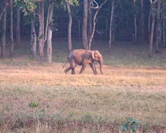
Simlipal National Park, Odisha (Orissa) Simlipal Wildlife - Taking its name from
the abundance of semul or red silk cotton trees that bloom vividly here, the
Simlipal National Park is home to three of India's biggest animal species
--Tiger, Asian Elephant and Gaur. Spread over a sprawling area of 2750 sq. kms,
the park is at an altitude of 559.31 meters. Set on a wide expanse of Sal
forest, this park is nestled in the very centre of Mayurbhanj, the northernmost
district of Orissa. Notable variations in topography, conducive climate and
required vegetation has supported large varieties of animals, birds and reptiles
to flourish in one of the earliest and finest of India's 15 Tiger reserves
falling under Project Tiger.

A forested, hilly terrain 200 km south-west of Kolkata, the reserve is endowed
with an exceptional biodiversity. Of the reserve's almost 1,000 species of
flowering plants, 94 are orchids, many of which are on show at the small display
at Gurguria. The reserve remains open from mid October to mid June.
An
entry permit needs to be taken from the office of Assistant Conservator of
Forest, National Park, Jashipur or from the Range Officer, Pithabata at
Pithabata. Check Gate to visit the reserve. The tourists can explore the reserve
from 0600 to 1200 hours in the day. This time is extended by two hours for the
reservation holders and is 0600 to 1400 hours.

With the nearest airports being at 250 and 300 kms at Calcutta and Bhubaneshwar
respectively, the reserve is 76 kms away from Lulung and 115 kms from Jashipur.
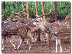
The fauna at the Park including tiger, leopard, elephants, bison, sambar,
porcupine, pangolin, flying-squirrel, hill myna, hornbill and pythons can be
observed closely by exploring the reserve in private jeeps and cars. But before
going on any such expedition, the tourists are advised to take an anti-malarial
drug.

Simplipal National Park, a tract of total wilderness is spread over an 845 sq km
core area. In the ancient days, this reserve was the hunting preserve of the
Mayurbhanj maharajas. As a result of excessive hunting, the wildlife here was
seriously damaged. And then it was in the year 1957 that a small area of it was
declared a sanctuary.
Today, the tiger reserve extends over 2,750 sq. km, within a larger area
of 4,374 sq km that constitutes the biosphere reserve. But unfortunately, the
tribal communities here still indulge in an annual ritual hunt (akhand shikar)
with bows and arrows. To add more to the woes of the animals, encroachment,
livestock grazing, poaching and indifferent visitors are also there. But the
management of the reserve has managed to sustain a vast variety of wild life
here despite nature's resilience. Better funding for effective protection and
awareness is therefore required at this stage to sustain healthy numbers of
animals.
|
|
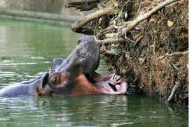
Nandan Kanan, Bhubaneswar, Odisha.
|

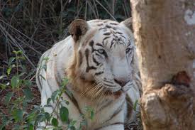
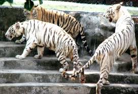
Nandankanan Zoological Park is a 400-hectare (990-acre) zoo and botanical garden
in Bhubaneswar, Orissa, India. Established in 1960, it was opened to the public
in 1979 and became the first zoo in India to join World Association of Zoos and
Aquariums (WAZA) in 2009. It also contains a botanical garden and part of it has
been declared a sanctuary. Nandankanan, literally meaning 'The Garden of
Heavens', is located near the capital city, Bhubaneswar, in the environs of the
Chandaka forest, and includes the 134-acre (54 ha) Kanjia Lake. A major upgrade
was done during 2000 (after the ruins caused by the super-cyclone of 1999 in
coastal Orissa). More than 2 million visitors visit Nandankanan every year.
|
|
|
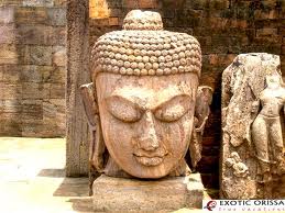
Ratnagiri, Jajpur, Odisha
|

Ratnagiri (Odia: ରତ୍ନଗିରି) was once the site of a mahavihara, or major Buddhist
monastery, in the Brahmani and Birupa river valley in Jajpur district of Orissa,
India. It was part of the Puspagiri University, together with Lalitgiri and
Udayagiri.
History Ratnagiri was established no later than the reign of the Gupta
king Narasimha Baladitya in the first half of the sixth century CE, and
flourished until the twelfth century CE. A Tibetan history, the Pag Sam Jon
Zang, identifies Ratnagiri as an important center in the development of the
Kalachakratantra in the 10th century CE, an assertion supported by the discovery
of a number of votive stupas, plaques, and other artifacts featuring Kalachakra
imagery.
Architectural features
A large-scale excavation was conducted at the site between 1958 and 1961,
uncovering much of what is known today. The main stupa dates to the 9th century
AD and was likely built on the site of an earlier, Gupta-era stupa. Seals were
found bearing the legend "Sri Ratnagiri Mahavihariya Aryabikshu Sanghasya,"
which helped identify it. Prominent, well-persevered standing statues of the
bodhisattvas Vajrapani and Padmapani can be found in niches in a portico.
Monastery No. 2 features a central paved courtyard flanked by a pillared veranda
around which are eighteen cells, a central shrine featuring an image of
Shakyamuni in varada mudra flanked by Brahma and Sakra, and elaborately
ornamented entrance porticos.

According to Amit Jha, a lecturer in the Department of History at Sri Aurobindo
College, Delhi University, "Ratnagiri comprises two magnificent monasteries,
also rebuilt more than once. One of them was double-storyed and had an extensive
courtyard with two-sides of it having a number of cells for habitation of monks.
Besides, we have archaeological remains of six temples, thousands of small
stupas, 1386 seals, myriad sculptural relics and architectural pieces of daily
use. The largest stupa was 47 feet (14 m) square and 17 feet (5.2 m) high
surrounded by four minor stupas. There are hundreds of miniature votive stupas
decorated with lotus, petal and beaded tassels." A museum now located on the
site displays statuary featuring Tara, Avalokiteshvara, Aparajita, and Hariti
have also been found, all in prototypical of Gupta style.
|
|
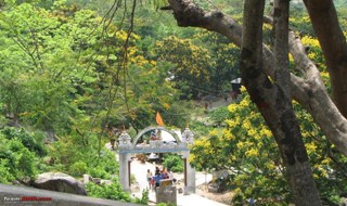
Sapta Sajya , Dhenkanal, Odisha
|
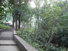
One can proceed 12 km in the Sankarpur road from Dhenkanal Bus stop and then
turn west at the Badagila chowk and pass two km to reach Saptya Sajya a scenic
beauty where the holy temple of Maryada Purusottama Sri Ramachandra is located
at about 900 feet at the hilltop. A mountains stream flows down as if touching
his holly feet in veneration. Mythologically this place is important and many
legends are still available. Its name is Sapta Sajya because, there are seven
hills surrounding the area. Again there is story that, the Saptarashi had their
ashramas here in this place.

There is also a mythological story, that, Sriram during his exiled or Vanabasha
had spent seven days in this beautiful spot. Secondly the Pandavas during their
12 years of exile and one year of Agyanta Vasa had chosen this mountains for
shelter. The Govt. constructed the Pukka road way in 1982. Inside the temple
complex Maa Annapurna temple was constructed in 1982, the 1st floor Kalki temple
in 1985, the Surya Narayan temple in 1990.
Now the temple of Sri
Rameswaram Shiva, Sri Ganesh, Sri Mahavir, and the Nabagrah Temple with each
room for each graha are found. Mahakali, Mata Saraswati, Sri Nrushingha temple
are conceived to be built in the holy complex. This scenic spot has become a
good tourist and picnic spot where thousands of tourists and devotees gather
from different corners of Odisha and India.
|
|
Khandadhar 1 , Keonjhar, Odisha
|
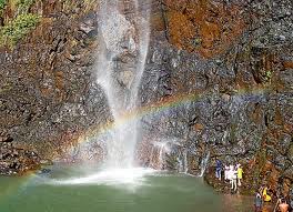
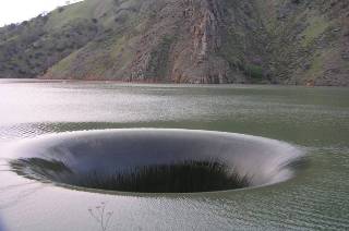
The Khandadhar Falls is located at Nandapani in Sundergarh district in the
Indian state of Orissa. It is the 12th highest waterfall in India.
Location
The Khandadhar Falls is 104 kilometres (65 mi) from Rourkela via Bonaigarh, and
60 kilometres (37 mile) from Kendujhar.
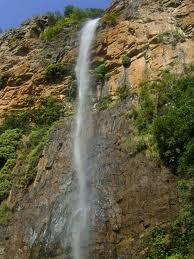
The falls
It is a perennial horse tail type waterfall. The Korapani Nala, a small stream,
plunges from a height of 244 metres (801 ft) in a single drop.
|
|
Kalijai Temple, Chilika, Odisha
|
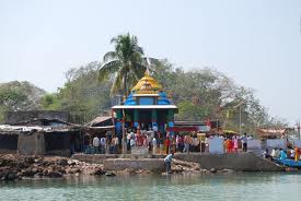
Kalijai Temple is located on an island in Chilika Lake. It is considered to be
the abode of the Goddess Kalijai. Highly revered by the local populace, the
deity has been venerated in the local folklores and legends. The island provides
an excellent destination for pilgrims as well as tourists. Every year in
January, a huge gala fair is held during the festival of Makar Sankranti.
Legend

A girl was newly married and was going to her husband in a boat.As her in-law's
house was inside an island in Chilika Lake it took a lot of time to reach.Orissa
coast is much prone to Cyclones and suddenly such a cyclone came and the boat
drowned inside the lake.All the Boatmen with her father were alive except that
Girl Jaai undiscovered.After the accidental death of that newly wed girl whose
name was Jaai she became goddess of people residing nearby area.And till now she
is worshipped as an Amsa of Kali,hence the name of the place.
|
|
Baliharchandi, Puri, Odisha
|

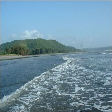
27 km to the south-west of Puri is the temple of Baliharachandi. Situated on a
sandy hill near the sea and adjacent to the mouth of the river Bhargavi, Goddess
Durga is worshipped here as Baliharachandi. The scenic beauty of this place is
ideal for group picnic.
|
|
Khandagiri, Bhubaneswar, Khurdha, Odisha
|
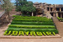
Udayagiri and Khandagiri Caves(Odia: ଉଦୟଗିରି ଓ ଖଣ୍ଡ଼ଗିରି ଗୁମ୍ଫା) are partly
natural and partly artificial caves of archaeological, historical and religious
importance near the city of Bhubaneswar in Orissa, India. The caves are situated
on two hills Udayagiri and Khandagiri, mentioned as Kumari Parvat in Hathigumpha
inscription and face each other across the road.

They have a number of finely and ornately carved caves. It is believed that most
of these caves were carved out huge residential blocks for the Jain monks,
during the reign of King Kharavela. Udayagiri meaning Sunrise Hill, has 18 caves
while Khandagiri has 15 caves.
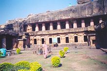
The caves of Udayagiri and Khandagiri, called lena or leṇa in the inscriptions,
were dug out mostly during the reign of Kharavela for the abode of Jaina
ascetics. The most important of this group is Ranigumpha in Udayagiri which is a
double storeyed monastery. Unfortunately, a number of the Jaina caves on the
Khandagiri side have encroachment problems, with local Brahmins turning them
into Hindu shrines and covering up some of the Jaina iconography.
|
|
Daringbadi, Balliguda, Phulbani, Odisha
|
Daringbadi,a Plateu and a beautiful area.The height is 3000ft above sea level.
It is an ideal summer resort which is popularly known as Kashmir of Odisha or
the heaven of odisha. This place is gifted with natural scenery like pine trees,
coffee gardens and beautiful valleys.
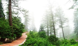
It is the only place in Orissa which experiences snow fall during Winter season.
Journy to the hills of Daringbadi is an experience in itself. This pretty hill
station is hundred kilometres from Phulbani and fifty kilometres from Balliguda.
The resting places are P.W.D. Inspection Bunglow. It is near from the capital of
odisha.The tourists will visit this place easity with their own
vehicles,bus,train,and also aeroplane.The journey from the plains to the hills
of Daringbadi is an experience in itself.
|
|
Paradeep Port, Jagatsinghpur, Odisha
|
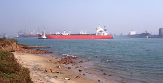
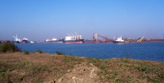
The importance of Paradeep and its beach is manifold. Besides being an
attractive tourist spot, the Paradeep beach in Orissa is also one of the most
important commercial sea port of the country. Paradeep which is actually an
estuary of the Mahanadi River, is one of the most popular beaches of Orissa.
Covered by green forests and adorned with natural creeks and island, the
Paradeep beach is a paradise for all marine lovers.
Paradip Port is a major seaport in Orissa, which is considered to be one of the
largest ports on the eastern coast of India. During 2009 - 2010, this port
recorded the handling of over 57 million tonnes of cargo, including thermal coal
and iron ore.
It is also the chief sea-borne trade centre in the Bay of Bengal, whose
foundation stone was laid in 1962 by the then Prime Minister of India, Pandit
Jawaharlal Nehru. Paradip Port has also been specially mechanised with iron ore
berths, cargo berths, container handling facilities and coal handling plants.
Close to the port lies the Paradip Beach at the convergence of the Mahanadi
River and the Bay of Bengal.
|
|
Kolab Dam, Koraput, Odisha
|
At an altitude of about 3000 ft. above sea level on river Kolab, stands the
majestic Kolab Reservoir generating Hydro Electric Power.15 km from Koraput, the
river Kolab makes a spectacular jump at Bagra to form a reservoir called the
“Upper Kolab Irrigation Project”. An ideal place for an outing, it is also a
panacea for city dwellers.

Kolab Botanical Garden stands beside the Majestic Kolab reservoir is ideal for
weekend picnic for people all over the district. This place is highly admired
for its scenic beauty, attracting tourists for weekend picnic and boating. Kolab
Botanical Garden stands beside the Majestic Kolab reservoir is ideal for weekend
picnic for people all over the district.

This place is highly admired for its scenic beauty, attracting tourists for
weekend picnic and boating. The well maintained botanical garden has over 200
varieties of flowering plants. Even the night view of the reservoir is worth
experiencing.
|
|
Duduma Waterfall, Koraput, Odisha
|
The majestic waterfall, also known as Matsya Tirtha falls from a height of 175
meters. A hydro electric project with its winch developed amidst deep greenery
is a place for pleasure.Three KMs away from Duduma waterfall, a small village of
Ankadeli draws the attention of foreign tourists to its weekly markets on
Thursdays where the most primitive tribe the Bondas, come from the remote,
inaccessible dense forest.Jolaput is known for its newly constructed dam
reservoir. The lake formed by the dam is 68.2 Sq. Kms. Its a picnic spot, 88 Kms
from Koraput.

It is 165 Mts. from Visakhapatnam on the river Machkund are the biggest water
falls of Andhra Pradesh. The water is diverted into the Machkund reservoir and
the over flow subsequently run throught a caryon. The Dumduma Falls on the River
Machhakunda is one of the most popular tourist spot in Orissa. The Dumduma Falls
is also known as the Matsya Tirtha and it is the site of the famous Machhakund
Hydro-Electric Project. The Dumduma Falls in the Eastern Ghats drops from a
height of about 157 meters and is categorized as a horsetail falls.

Investigation and research on the Dumduma Falls began in the year 1941 when the
plan for generating hydro-electric power was chalked out. It was around the year
1946, that the scheme was implemented. 104cfs are drawn from the Dumduma hydro
electrical plant which hints at the fact that that this waterfall in Orissa is
still very active.
|
|
Gupteswar Temple, Koraput, Odisha
|
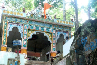
Gupteswar is a cave temple located on the banks of Kolab River, about 80 km from
Koraput.Important cave shrine of Lord Shiva Situated on a lime stone hill amidst
scenic bliss.
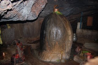
The temple houses a sacred swayambhu Shivling called Gupteswar, which literally
means the ‘Hidden God.
Shivratri is the major festival celebrated here
amidst much pomp and splendor.

The fame of the temple is not restricted to Orissa but it is also well known in
other parts of the country. The people of Chhattisgarh refer to the shrine by
the name Gupta Kedar. Gupteswar can be reached through a forest tract which
starts from the east of the Ramagiri Hill up to a distance of 19 km.
|
|
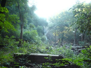
Tikarpada, Angul, Odisha
|
Satkosia wildlife sanctuary is one of the most beautiful wildlife sanctuaries in
India as well as very important eco-tourism site. The down stream of River
Mahanadi after Hirakud Dam flows through a stunning 22KM narrow gorge (1,500 to
2,500 ft high) of Satkosia before falling into the Bay of Bengal.It is located
in the districts of Angul, Nayagarh and Boudh. The Satkosia Gorge Sanctuary is
extended in an area of 745.52 sq.km. with a rare place of beauty where nature is
generously bountiful in all its forms of flora and fauna. Here, the River
Mahanadi divides the entire area into two parts which are accessible from two
separate districts- Nayagarh and Boudh. On the south of the river is a high
range of hills and on the north are the mountainous parts of Athamallik and
Angul subdivsions. The scenic beauty of Satkosia with its undulating mountain
skyline is mesmerising. The sylvan beauty of the forest with captivating
fragrance is simply bewildering.

The meandering Mahanadi flowing closeby amidst bountiful hills, forms here the
mightiest gorge of India, twenty-two km long. The nature camp is located on the
banks of Mahanadi. The camps have 10 tents with separate toilet facility (Indian
style) on the back of the each tent. Each tent has two camp type beds,
comfortable enough for a good night sleep. Blankets are provided as it gets real
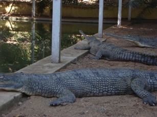
chilly in the winter times. 5 of the tents are called Gharials (alligators) and
5 of the other ones are called Maggars (crocodiles).

It is acclaimed as one of the World's most enchanting spot. The place is ideal
for boating, angling and adventure. The forests and hills around the village
have varieties of fauna to fascinate the visitors. A Gharial Crocodile
Sanctuary, setup here, has enhanced the importance of the place.
|
|
Hirakud Dam, Sambalpur, Odisha
|
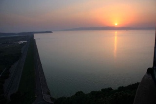
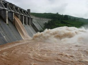
Hirakud Dam built on Mahanadi River is the longest dam in India. The overall
length of the main dam is 4.8 km, and the total length is 25.8km with dam and
dykes taken together. The dam is about 15 km upstream of Sambalpur town in State
of Orissa and was the first post independence major multipurpose river valley
project in India. The dam irrigates 436000 ha of CCA in Mahanadi delta and has
an installed capacity of 307.5 MW. Hirakud Dam is a composite structure of
Earth, Concrete and Masonry. Hirakud Dam intercepts 83400 sq. km (32200 sq
miles) of Mahanadi catchments. It has a reservoir spread of 743 sq km at full
reservoir level and the reservoir has a storage of 5818 M. Cum with gross of
8136 M Cum.

Hirakud Dam is built across the Mahanadi River, about 15 km from Sambalpur in
the state of Orissa in India. Built in 1956, the dam is the worlds largest
earthen dam.[1] Behind the dam extends a lake, Hirakud Reservoir, 55 km long.
Hirakud Dam is one of the longest dams in the world, about 16 mi (26 km) in
length. It was the first major multipurpose river valley project started after
Indias independence.Construction history.

Before the devastating floods of 1937, Sir M. Visveswararya proposed a detailed
investigation for storage reservoirs in the Mahanadi basin to tackle the problem
of floods in the Mahanadi delta. In 1945, under the chairmanship of Dr. B. R.
Ambedkar, the then Member of Labour, it was decided to invest in the potential
benefits of controlling the Mahanadi for multi-purpose use. The Central
Waterways, Irrigation and Navigation Commission took up the work.
|
Sponsored Links
|
|
|
|